

Bushfire Preparedness 2026-2027
Living amongst Armadale's beautiful bushland offers a unique connection to nature, but it also comes with a shared responsibility to prepare for bushfire risk. Bushfires can occur every season and taking simple steps now can help protect your home, your family and community.
There is a comprehensive collection of Bushfire and Emergency information on the City's website but some of the key information has been summarised for you here.
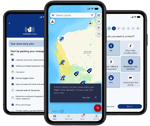 Creating an emergency plan is the best way to stay safe. Whether you live in a rural area or in the suburbs everyone needs to be prepared. Creating a plan takes only 15 minutes and can make all the difference during a bushfire emergency. Talk about the plan at home, include children and practice what you will do together.
The emergency planning tool within Emergency WA provides one place to prepare, store, print, share and update your emergency plan at any time, from any device. Creating an emergency plan in the app and attaching it to your watch zone means you'll be instantly notified when disaster strikes. Emergency WA will deliver your plan back to you when you need it most, helping you act quickly and confidently.
Prepare for a bushfire now and help keep yourself, your family and your household safe by creating your emergency plan today.
One of the most important steps is ensuring your property complies with the City's Firebreak and Hazard Reduction Notice 2026/2027.
- Mandatory Dates: Firebreaks and works outlined in the Firebreak and Hazard Reduction Notice must be installed by 1 December and maintained through to 31 March.
- Summary of Firebreak requirements:
- Land over 5,000 m² must have a 3 metre wide, 4 metre high firebreak installed within 10 metres of the boundary and around all structures
- Land 5,000 m² or less must ensure all flammable material on the entire property (not including living trees, shrubs or plants) does not exceed 5cm in height
- On all properties keep roofs, gutters and walls of habitable buildings clear of inflammable matter and maintain a 3 metre wide, 4 metre high driveway
- Variations: If you are unable to meet the property requirements outlined in the Firebreak and Hazard Reduction Notice, you should submit your application to vary by 1 October
- Compliance: City Rangers will start conducting annual property inspections from 1 December. Non-compliance may result in penalties, but more importantly may put your property and community at risk.
 Burning of Garden Refuse
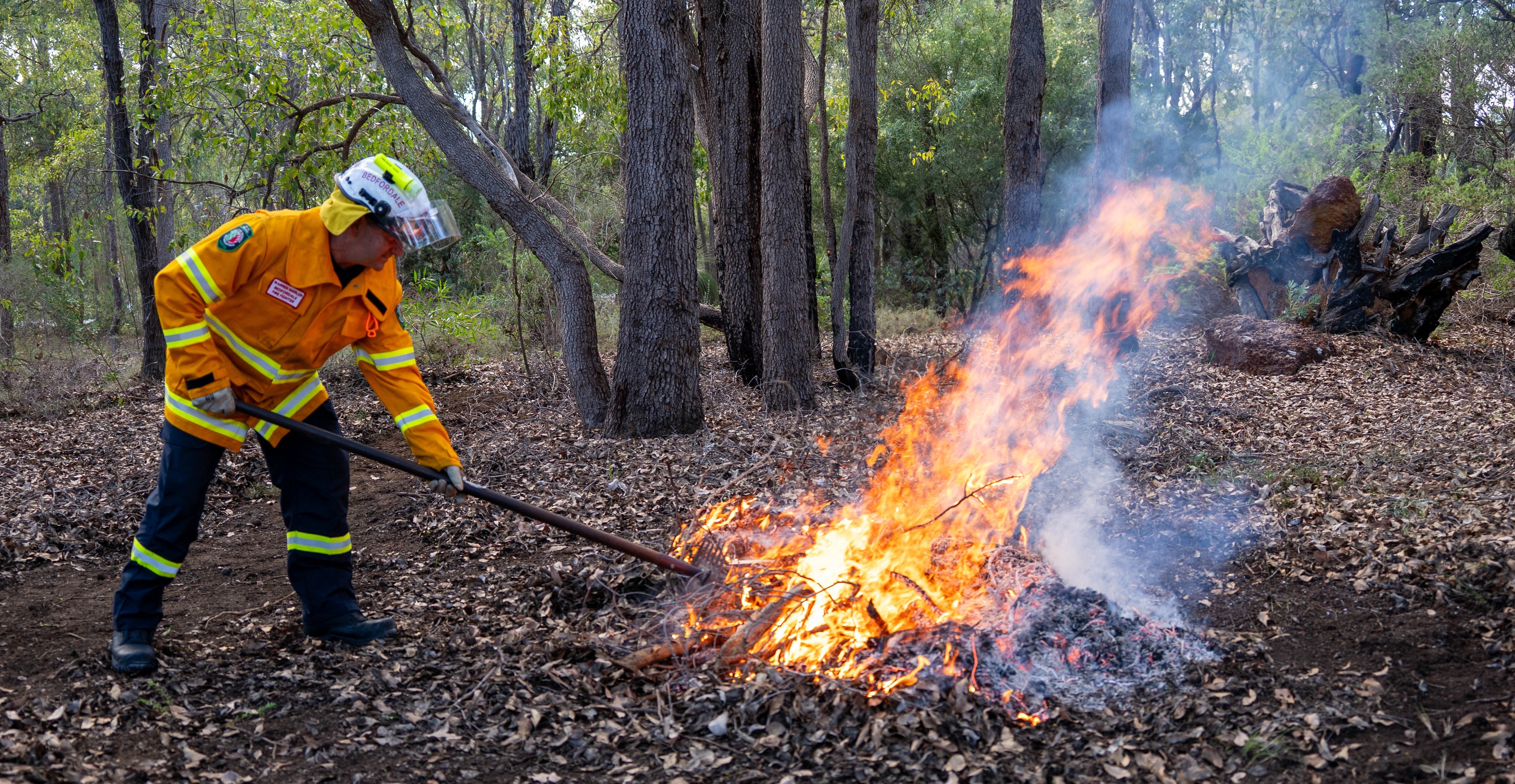
You can burn small piles no larger than 1 cubic metre of garden refuse without a permit providing you follow the below conditions:
- The fire is lit between 6pm and 11pm and is to be completely extinguished by midnight
- At least one person stays with the fire until it is completely extinguished by the application of water or earth
- There is no inflammable matter within 5 metres of the fire
- Only burn one pile at a time
- Register your burn with DFES Communication Centre on (08) 9395 9209 and inform neighbours
- If the materials are likely to cause a smoke nuisance, including plastic, rubber, green garden waste or wet material
Burning is prohibited on Sundays and Public Holidays, on properties less than 1,200m2 when the Fire Danger Rating is High or above or a Total Fire Ban or Harvest and Vehicle Movement Ban has been declared.
Permits
A permit to burn is required when burning garden refuse, bush or trees larger than 1 cubic metre or if you want to burn outside of the 6 pm to 11pm timeframe. Permits are free and can be obtained from City’s Administration Office on Monday, Wednesday and Friday between 3pm-4pm or you can complete the online application form from the City’s website and submit at least three (3) business days prior to the intended burn time.
Burn Smart
Undertaking a planned burn is a significant responsibility and involves a lot of preparation. In the wrong conditions, planned burns can escape and become a bushfire. Burn SMART resources have been developed targeted towards small landholders with a property of two hectares or less. For valuable tips and resources visit DFES - Planned Burning.
For more information on burning restrictions and permits or to get the answers to our FAQs, visit the burning restrictions, permits to burn and hazard reduction burns section of our website.
Fire Danger Ratings predict and describe the potential level of danger should a bushfire start. The City of Armadale falls within two fire weather districts, being Swan Inland South and Swan Coastal South. You can find the daily fire danger ratings for your property by visiting Emergency WA. There are also Fire Danger Rating Information Boards located on Albany Highway and Brookton Highway which are updated daily.
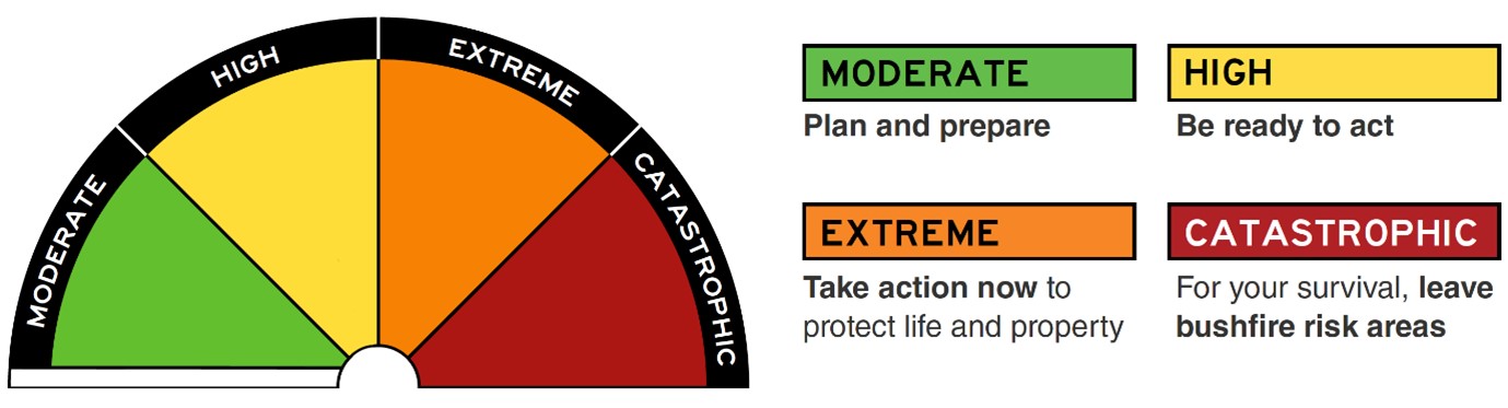
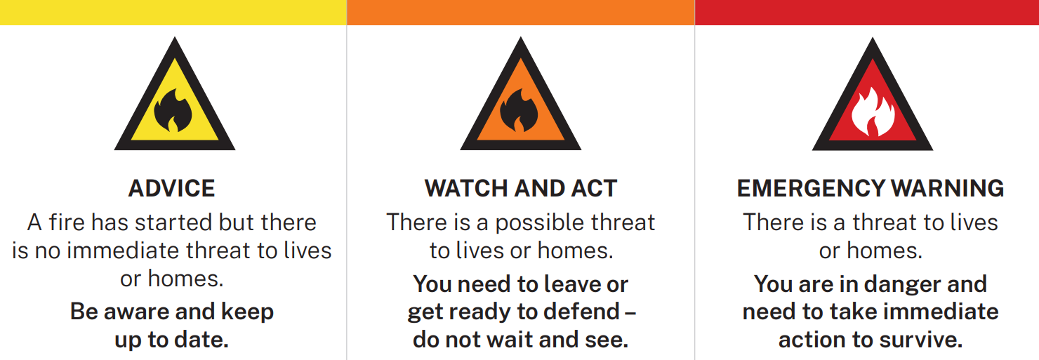
The Australian Warning System provides information about the level of threat from an active bushfire and the actions you should take to stay safe. The warning level icons and colours change to reflect the increasing risk to life or property.
Living amongst Armadale's beautiful bushland offers a unique connection to nature, but it also comes with a shared responsibility to prepare for bushfire risk. Bushfires can occur every season and taking simple steps now can help protect your home, your family and community.
There is a comprehensive collection of Bushfire and Emergency information on the City's website but some of the key information has been summarised for you here.
Creating an emergency plan is the best way to stay safe. Whether you live in a rural area or in the suburbs everyone needs to be prepared. Creating a plan takes only 15 minutes and can make all the difference during a bushfire emergency. Talk about the plan at home, include children and practice what you will do together.The emergency planning tool within Emergency WA provides one place to prepare, store, print, share and update your emergency plan at any time, from any device. Creating an emergency plan in the app and attaching it to your watch zone means you'll be instantly notified when disaster strikes. Emergency WA will deliver your plan back to you when you need it most, helping you act quickly and confidently.
Prepare for a bushfire now and help keep yourself, your family and your household safe by creating your emergency plan today.
One of the most important steps is ensuring your property complies with the City's Firebreak and Hazard Reduction Notice 2026/2027.
- Mandatory Dates: Firebreaks and works outlined in the Firebreak and Hazard Reduction Notice must be installed by 1 December and maintained through to 31 March.
- Summary of Firebreak requirements:
- Land over 5,000 m² must have a 3 metre wide, 4 metre high firebreak installed within 10 metres of the boundary and around all structures
- Land 5,000 m² or less must ensure all flammable material on the entire property (not including living trees, shrubs or plants) does not exceed 5cm in height
- On all properties keep roofs, gutters and walls of habitable buildings clear of inflammable matter and maintain a 3 metre wide, 4 metre high driveway
- Variations: If you are unable to meet the property requirements outlined in the Firebreak and Hazard Reduction Notice, you should submit your application to vary by 1 October
- Compliance: City Rangers will start conducting annual property inspections from 1 December. Non-compliance may result in penalties, but more importantly may put your property and community at risk.
Burning of Garden RefuseYou can burn small piles no larger than 1 cubic metre of garden refuse without a permit providing you follow the below conditions:
- The fire is lit between 6pm and 11pm and is to be completely extinguished by midnight
- At least one person stays with the fire until it is completely extinguished by the application of water or earth
- There is no inflammable matter within 5 metres of the fire
- Only burn one pile at a time
- Register your burn with DFES Communication Centre on (08) 9395 9209 and inform neighbours
- If the materials are likely to cause a smoke nuisance, including plastic, rubber, green garden waste or wet material
Burning is prohibited on Sundays and Public Holidays, on properties less than 1,200m2 when the Fire Danger Rating is High or above or a Total Fire Ban or Harvest and Vehicle Movement Ban has been declared.
Permits
A permit to burn is required when burning garden refuse, bush or trees larger than 1 cubic metre or if you want to burn outside of the 6 pm to 11pm timeframe. Permits are free and can be obtained from City’s Administration Office on Monday, Wednesday and Friday between 3pm-4pm or you can complete the online application form from the City’s website and submit at least three (3) business days prior to the intended burn time.
Burn Smart
Undertaking a planned burn is a significant responsibility and involves a lot of preparation. In the wrong conditions, planned burns can escape and become a bushfire. Burn SMART resources have been developed targeted towards small landholders with a property of two hectares or less. For valuable tips and resources visit DFES - Planned Burning.
For more information on burning restrictions and permits or to get the answers to our FAQs, visit the burning restrictions, permits to burn and hazard reduction burns section of our website.
Fire Danger Ratings predict and describe the potential level of danger should a bushfire start. The City of Armadale falls within two fire weather districts, being Swan Inland South and Swan Coastal South. You can find the daily fire danger ratings for your property by visiting Emergency WA. There are also Fire Danger Rating Information Boards located on Albany Highway and Brookton Highway which are updated daily.
The Australian Warning System provides information about the level of threat from an active bushfire and the actions you should take to stay safe. The warning level icons and colours change to reflect the increasing risk to life or property.
-
Take Survey
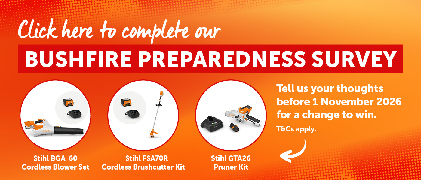
The City is wanting to understand the bushfire awareness and preparedness of our community to assist in targeting our community education programs effectively - and we need your help!
As a thank you, valid entries will go in the draw to win one of three awesome prizes:
1st Prize: Stihl BGA 60 Cordless Blower Set RPP $629
2nd Prize: Stihl FSA70R Brushcutter Cordless Kit RPP $549
3rd Prize: Stihl GTA26 Pruner Set RPP $279Terms and conditions for the prize draw can be viewed here
Share Bushfire Preparedness Survey 2026 on Facebook Share Bushfire Preparedness Survey 2026 on X (formerly Twitter) Share Bushfire Preparedness Survey 2026 on Linkedin Email Bushfire Preparedness Survey 2026 link
-
Firebreak and Hazard Reduction Notice Issued
Bushfire Preparedness 2026-2027 has finished this stageThe works outlined in the Firebreak and Hazard Reduction Notice must be completed by 1 December 2026 and maintained up to and including 31 March 2027.
Variations
If you consider it impractical to meet a requirement/s of the Firebreak and Hazard Reduction Notice, you may apply to the City for a variation no later than 1 October 2026. -
Restricted Burning Time: 1 October - 30 November 2026
Bushfire Preparedness 2026-2027 is currently at this stageBurning is permitted under specific conditions and a permit may be required depending on the time and type of burn. For more information, visit the City's website.
-
Prohibited Burning Time: 1 December 2026 - 31 March 2027
this is an upcoming stage for Bushfire Preparedness 2026-2027No burning permitted at any time. Solid fuel barbeques, pizza ovens and smokers are not permitted.
Firebreaks
Must be installed by 1 December and maintained until 31 March 2027 -
Restricted Burning Time: 1 April - 31 May 2027
this is an upcoming stage for Bushfire Preparedness 2026-2027Burning is permitted under specific conditions and a permit may be required depending on the time and type of burn. For more information, visit the City's website.

-
 Click here to play video
Small Pile Burn - Emergency Services Education Series
Click here to play video
Small Pile Burn - Emergency Services Education Series
-
 Click here to play video
Property Preparedness - Emergency Services Education Series
Click here to play video
Property Preparedness - Emergency Services Education Series
-
 Click here to play video
Emergency Planning - Emergency Services Education Series
Click here to play video
Emergency Planning - Emergency Services Education Series
-
 Click here to play video
Firebreak Requirements - Emergency Services Education Series
Click here to play video
Firebreak Requirements - Emergency Services Education Series
-
 Click here to play video
Bushfire Mitigation Works in City Reserves - Emergency Services Education Series
Click here to play video
Bushfire Mitigation Works in City Reserves - Emergency Services Education Series
-
 Click here to play video
Emergency WA App - Emergency Services Education Series
Click here to play video
Emergency WA App - Emergency Services Education Series
-
City of Armadale
Phone 9394 5000 Email info@armadale.wa.gov.au